According to Valerie Mah’s The ‘Bachelor’ Society, in July 1900, a Chinese resident was listed at 139 Queen Street West. At that time, 139 Queen St. West was a laundromat. The building itself was owned by Edward and Margaret Hodgekinson, and they rented the location to Charlie Mark. 139 Queen St. West was part of Ward 3 in Division 4.
Works sourced:
139 Queen St. West. City of Toronto Assessment Rolls. Toronto: 2002. Microfilm.
/wp-content/uploads/2013/04/countercultureslogopart3-300x106.png00njurado/wp-content/uploads/2013/04/countercultureslogopart3-300x106.pngnjurado2014-04-14 18:27:152014-04-14 21:38:59The Chinese in Early 20th Century Toronto: 139 Queen St. W
In 1901, a man named Hong Kee lived in the building at 207 Church Street. The building also housed his business, which was a laundromat. According to the 1913 Fire Insurance Map, it was built out of wood. Hopefully the steam from the laundry did not rot the wood. Though there are no pictures of the building to be found, if it was anything like the back of 203 Church Street in 1914 (see picture), it was possibly somewhat rundown.
At this time, there were two other people living with him (three total), who presumably helped run the laundry. Valued at $1005 dollars and deemed “Anglican” in official Assessment records, the building was not owned by Kee, but was instead owned by Kenneth Allison, who lived elsewhere at 668 Yonge Street.
Allison still owned the building by 1909, at which time Kee was 30 years old. By this time though, there now only lived two people in the building. Kee did not have any children with him. In 1909 the property was valued at $1225, which was a slight improvement from 1901, though it’s uncertain whether this was due to improvement of the building, success of the business, or differences in dollar value. Perhaps all three.
Works Cited
City of Toronto Assessment Roll, Ward 3 Div. 2, Reel 216
City of Toronto Assessment Roll, Ward 3 Div. 2, Reel 147
Toronto Fire Insurance Plan (1913)
/wp-content/uploads/2013/04/countercultureslogopart3-300x106.png00matthew.humphries/wp-content/uploads/2013/04/countercultureslogopart3-300x106.pngmatthew.humphries2014-04-14 18:22:052017-06-14 02:07:34The Chinese in Early 20th Century Toronto: 207 Church Street
In 1913, 352 Spadina Avenue was part of a string of houses owned by Mary Leadly and Percival Leadly (they owned units 350 to 358)
Two tenants were listed at this address. The first was Louis Wong age 26, who lived on the bottom section of the unit. It was a laundry business in this bottom section, like most real-estates nearby. The number of residents living here including Wong is two. The second tenant was a Frank Tilley age 39, lived on the higher level of the 352 Spadina Ave establishment. The business title given to the tenant is a Collector. The number of residents living on the top section is 6 including Frank. Currently, this location is a Jewellery shop called Minh Chau Jewellery & Watches.
Sources
Title: City of Toronto Assessment Rolls, 1913
/wp-content/uploads/2013/04/countercultureslogopart3-300x106.png00Eman Ventolero/wp-content/uploads/2013/04/countercultureslogopart3-300x106.pngEman Ventolero2014-04-14 18:16:462014-04-14 21:39:31The Chinese in Early 20th Century Toronto: 352 Spadina Avenue
The residential building was located on what is now Dundas St. W. at Dennison Rd. It was owned by Joseph O’Patterson from 1899 to 1901. This building was a wooden building that stayed wooden for more than twenty years according to fire insurance plans. During the time frame of 1899 to 1901 the building had different tenants. Spark Williams lived in this building with two adults from the end of the 19th century until 1900. In 1903, a new name shows up on the tax records: George Hutchington. Mr. Hutchington lived with three other people, none of them children. A factor that did stay the same was that all of the residents throughout the years observed were listed as Protestant. The building has since been torn down, and it is currently a vacant business place, but the upper floor is home to about twenty tenants, the majority of them being students. This building is two blocks away from the heart of Toronto’s Chinatown and is currently owned by a Chinese immigrant.
Works Cited
Assessment Roll: Ward 4 Division 2 1899. Toronto Archives.
Assessment Roll: Ward 4 Division 2 1900. Toronto Archives.
Assessment Roll: Ward 4 Division 2 1901. Toronto Archives.
Goads Fire Insurance Plan: Central Toronto (1899); Toronto Archives Website
Goads Fire Insurance Plan: Central Toronto (1924); Toronto Archives Website
/wp-content/uploads/2013/04/countercultureslogopart3-300x106.png00Daniel Gomez-Ortega/wp-content/uploads/2013/04/countercultureslogopart3-300x106.pngDaniel Gomez-Ortega2014-04-14 18:12:112014-04-14 21:39:51The Chinese in Early 20th Century Toronto: 189 St. Patrick St (now 608 Dundas St. W.)
According to the book called The Chinese in Toronto from 1878 by Arlene Chan, in 1902 this address was operated as a Chinese Tea shop along with other tea shops such as Lee Chong Yung at 154 York street, Yee Quong Teas at 1561/2York Street, and Kwon Yong Loy at 85-87 Queen Street East. This tea shop was owned and operated by Quong Ying Yune. It was part of Toronto’s first Chinatown back (1878-1960). Currently, the Thompson Building in the Sheraton Centre is on the location of the former tea shop.
References:
1. Chan, Arlene. The Chinese in Toronto from 1878: from outside to inside the circle. Toronto: Dundurn Press, 2011. Print.
2. Qiu, Paul . “Changes to Toronto’s Chinatown: Toronto’s First Chinatown and Downtown Chinatown | CCNC Toronto Chapter.” Chinese Canadian National Council Chapter . N.p., n.d. Web. 11 Apr. 2014. .
/wp-content/uploads/2013/04/countercultureslogopart3-300x106.png00hayi/wp-content/uploads/2013/04/countercultureslogopart3-300x106.pnghayi2014-04-14 18:10:012014-04-22 18:32:17The Chinese in Early 20th Century Toronto: 69 1/2 Queen Street West
In a July 1900 letter to Rev. Mackay noted in Valerie’s Mah’s Bachelor Society , 175 St. Patrick Street was an address associated with early Chinese immigrants to the city of Toronto. 175 St. Patrick Street was located at the intersection of what is now Dundas Street West and Kensington Road. In 1899, according to tax documents, eight people were residing in this brick residence, three of them children, suggesting it to be a residence for multiple people, possibly immigrants. It was owned by Robert Crates, but the main tenant was Robert McLelland. It is possible that some of the other residents may have been Chinese since the location was relatively close to where old Chinatown used to be. In 1901 the ownership of the building changed hands. Robert McLelland became not only the tenant but the taxable owner as well of the building. The number of residents did not change. This building has since been torn down and is now part of a public housing complex only a block away from the heart of Chinatown at Spadina St. and Dundas St. W.
Works Cited
Assessment Roll: Ward 4 Division 1 1899, Toronto Archives.
Assessment Roll: Ward 4 Division 1 1900, Toronto Archives.
Assessment Roll: Ward 4 Division 1 1901 Toronto Archives.
Goads Fire Insurance Plan: Central Toronto (1899); Toronto Archives Website
Goads Fire Insurance Plan: Central Toronto (1924); Toronto Archives Website
/wp-content/uploads/2013/04/countercultureslogopart3-300x106.png00Daniel Gomez-Ortega/wp-content/uploads/2013/04/countercultureslogopart3-300x106.pngDaniel Gomez-Ortega2014-04-14 18:07:592014-04-14 21:40:50The Chinese in Early 20th Century Toronto: 175 St. Patrick St. (1899) (now 567 Dundas St. W.)
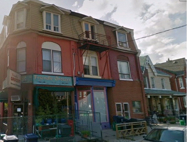
In Valarie Mah’s paper Bachelor Society, in 1900, 82 Gladstone Avenue was occupied by Chinese immigrant Lew Mo Kee. According to the city directories, 82 Gladstone was vacant before Kee resided in 1900-1901 being the first Chinese resident to make it a laundry business. After his departure in 1901, another Chinese resident, Bong Mark, continued the laundry business and after 4 years in 1905, the business previously occupied by Wood Yong still remained. It appears the occupation of running a laundry lacked permanence and was a mere response to “the demand of rapidly growing urban economy by providing quality, low cost laundry service to a workforce of single men” (Mah, 40). Interestingly, prior to Kee’s moving, 82 Gladstone in 1898 was a Public School with the tenant and caretaker, Ritchie Duncan. The progression of this area is evident through the changes of residence and the use of building.
According to taxes of 1901, Kee was a tenant at 82 Gladstone which was owned by Matthew Parsons, owner and trustee of the Presbyterian Church. Mah reports there are three other Chinese immigrants taking residence in the same building. However, observing the accessible rolls of 1900 in Ward 6 division 2, it seems that this number may be an error and that there were actually five individuals are connected to the residence. In others words, it is possible that Kee was living with his family in 82 Gladstone Avenue. Chinese immigrants living with their families in the early 1900s were, however, a rare phenomenon. Most in men in Toronto Chinatown were “bachelors” and “there were only 13 Chinese families among 2035 Chinese in the city in 1921(Mah, 37), therefore there must have been even less Chinese families in Toronto in 1900. Furthermore, a headtax for Chinese coming into Canada had been established and the “$50 a head was a financial hardship” for the Chinese making it very hard to believe that the residents as 82 Gladstone Avenue were Lew Mo Kee’s actual family (Mah, 27).
Currently, 82 Gladstone Avenue is a grocery store called “Friendly Grocery”.
Works Cited:
Mah, Valerie. “The “Bachelor” Society”. A Look at Toronto’s Early Chinese Community from 1878 – 1924 (unpublished, 1978).
Google Maps: 82 GLadstone Avenue. https://maps.google.ca/maps?hl=en-CA&gbv=2&q=82+gladstone+avenue&ie=UTF-8&hq=&hnear=0x882b3455204114fb:0x42d42d4448af7867,82+Gladstone+Ave,+Toronto,+ON+M6J+3K7&gl=ca&ei=S7dIU7CUO6qw2wWL9ICADg&ved=0CB4Q8gEoATAA. Web. Last accessed 11 April ,2014.
Toronto City Directory (1898-1902, 1905); Toronto Archives
Google map:
Goads Fire Insurance Plan (1899); Toronto Archives Website
/wp-content/uploads/2013/04/countercultureslogopart3-300x106.png00michelle/wp-content/uploads/2013/04/countercultureslogopart3-300x106.pngmichelle2014-04-14 18:03:592014-04-14 21:41:11The Chinese in Early 20th Century Toronto: 82 Gladstone Avenue
Based on the information obtained about this address from the City of Toronto Archives/City Directory, in 1900, 133 Argyle was owned by James and Heffer, however the tenant was Charlie Louie. When Louie was at this address, according to the Toronto Assessment Rolls, he was conducting a laundry business. The Assessment Rolls also indicate that Louie was identified as a 41 year old Christian man and was the only person living at the address. He had no family members with him. Twenty years later (1920), Charlie was still doing the laundry business at this address.
The images below shows Argyle Street in the early 20th century.
/wp-content/uploads/2013/04/countercultureslogopart3-300x106.png00hayi/wp-content/uploads/2013/04/countercultureslogopart3-300x106.pnghayi2014-04-14 17:57:192014-04-22 18:35:41The Chinese in Early 20th Century Toronto: 133 Argyle
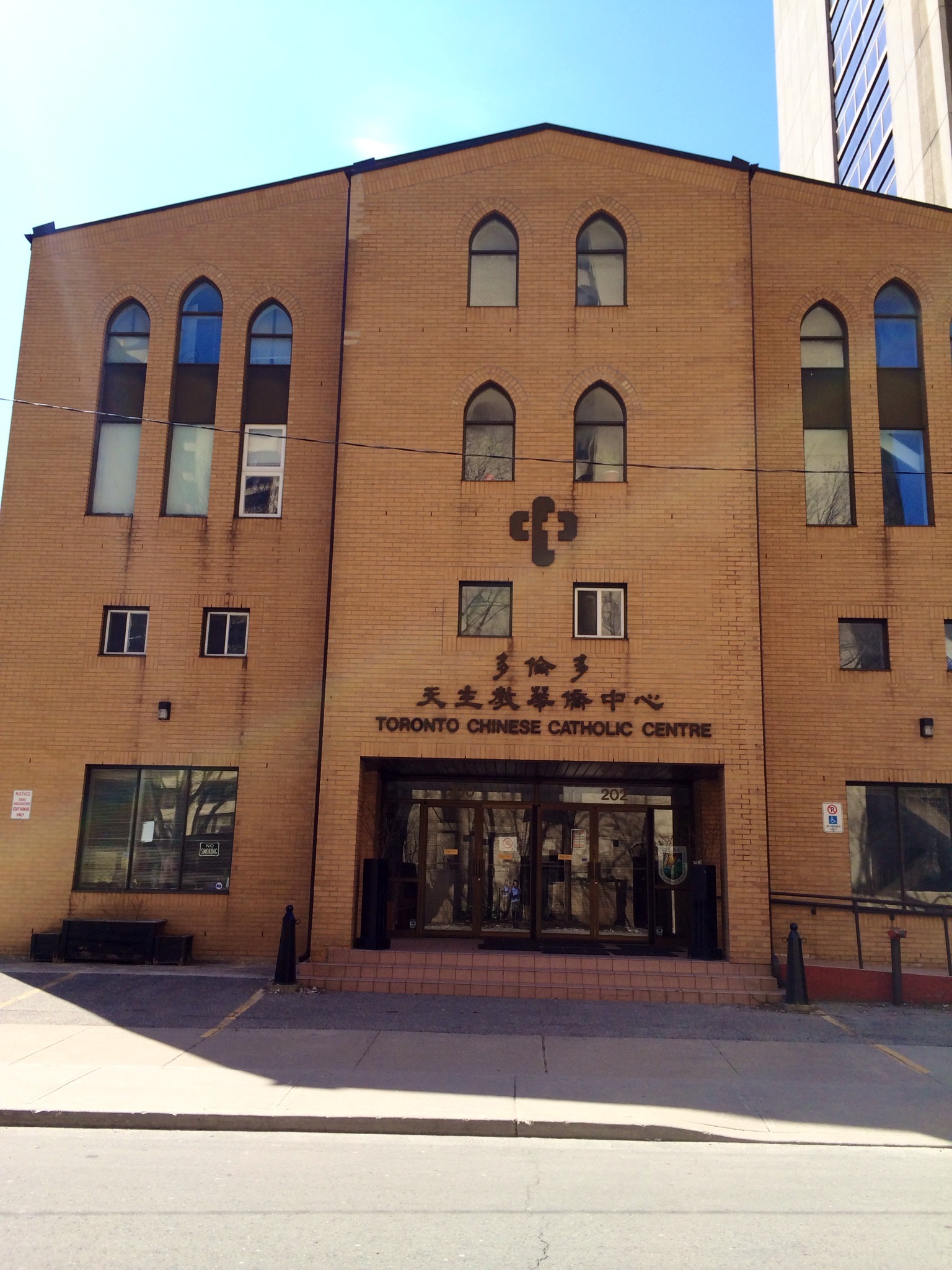
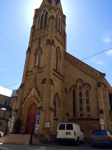
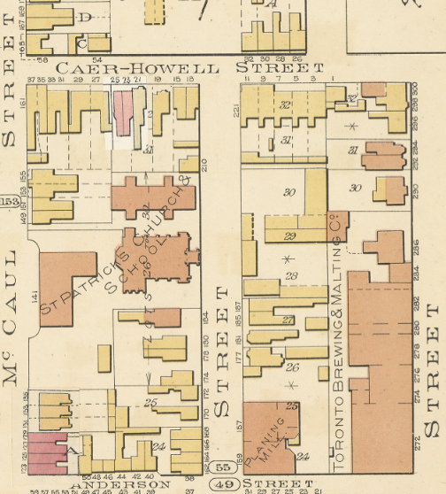
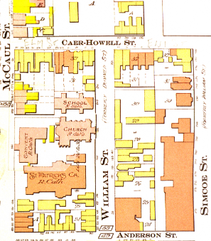
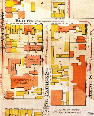
202 St. Patrick Street in Toronto, Ontario is currently a community centre for those of Chinese heritage. The Toronto Chinese Catholic Centre is connected to a Chinese Roman Catholic Church entitled “Our Lady of Mount Carmel Church”. However, 202 St. Patrick Street was not always a community centre. Through the assistance of the City of Toronto Archives, I was able to conclude that the location was actually a Roman Catholic school in the early 1900s. In fact, the location was not even known as “202 St. Patrick Street”. Pre-1900s to 1920’s, the street St Patrick was called Williams Street and the lot number was 208. William Street intersected with Caer-Howell Street (now Elm Street) and Anderson Street (now Dundas St. West). The name of the school is referenced in the maps as “St. Patrick’s School”, however, in other records, the name is disclosed.
Even in the early 1900s, the school (along with other prominent establishments, like the “Planning Mill”) was one of the few brick-built structures in the area. Most houses near the school were wooden . The school and church were able to build an additional cathedral beside “Our Lady of Mount Carmel” by the year 1913, the reason is unknown. By 1913, the school was now considered as lot 202 but the street name was still Williams Street.
1989
1913
1924
Assessment Role Findings
202 St. Patrick Street was classified as “separate school” in the 1901 Assessment Roles. This is important because it was not considered a public establishment, thus the taxation rate was paid differently. The owner name is indicated by 1914. “J. Hall” who lives at 28 Duke Street was considered the owner of the school at the time. As the 1922 Assessment Role indicates, “J. G. Hall” seems to keep the building through the 1920’s as well.
The size of the lot was 79×126 meters. This lot size remains unchanged from 1901 through 1922 showing a lack of additions made to school over the years. Another indication that the building was not added to is the “Value of the Building”. The “Value of the Building” remains at $4000 throughout the years 1901 through 1922. However, the “Value of Land” began to increase substantially. The land cost grew from $3160 in 1901 to $8690 in 1913.
The number of tenants is always listed as “X” indicating there is nobody who was living at 202 St. Patrick Street at any point of its establishment. Another (rather obvious) side note is that the school is labelled “Exempt” when mentioning livestock or crop production.
/wp-content/uploads/2013/04/countercultureslogopart3-300x106.png00Matteo Cianfrone/wp-content/uploads/2013/04/countercultureslogopart3-300x106.pngMatteo Cianfrone2014-04-14 17:53:322014-04-14 21:42:21The Chinese in Early 20th Century Toronto: 202 St. Patrick Street
According to the city of Toronto directories, 636 Yonge Street, was non-existent in 1880 and in 1900. However, in the 1920 City Directories, the address appeared, as did the name of tenant. Based on the city directories, at this address a Chinese Laundry business was being operated by Sam Wo, the tenant of the address at the time. More information on this address was not found on the City Assessment Rolls of 1920, but it was found for 10 years later (1930). In 1930, this address was still being operated as a Chinese laundry by Sam Wo, who at the time, was 52 years of age. The owner of the address at the time was ‘Mcwhimmery William’. On the assessment rolls it showed that Sam Wo’s religion was identified as ‘Chin’.
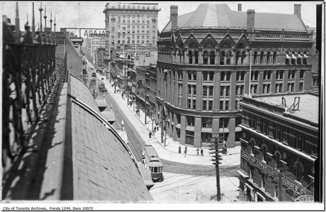
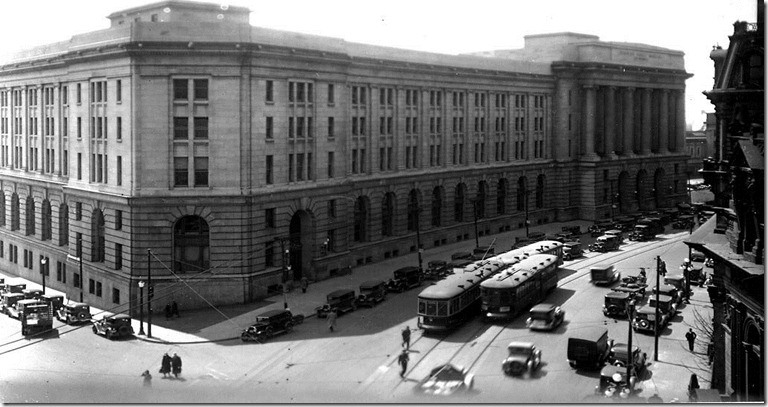
There were no specific old pictures found of this address, however, the uploaded pictures here just show how yonge st looked like in 1912 and in 1934. These pictures were taken online from ‘Toronto’s amazing intersection at Yonge and Front Streets’: http://tayloronhistory.com/2013/03/25/torontos-amazing-intersection-at-yonge-and-front-streets/
/wp-content/uploads/2013/04/countercultureslogopart3-300x106.png00hayi/wp-content/uploads/2013/04/countercultureslogopart3-300x106.pnghayi2014-04-14 17:51:192014-04-22 18:37:09The Chinese in Early 20th Century Toronto: 636 Yonge Street